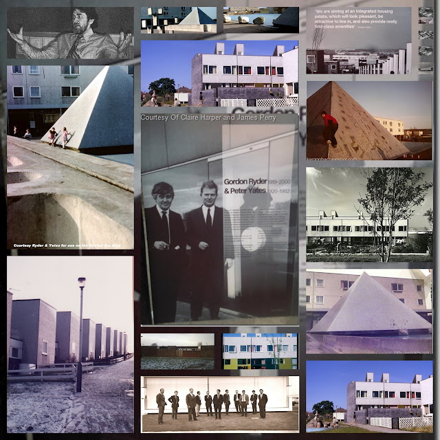
Parks on Kenton Bar Estate
There was only really one park-the one at the border between Kenton Bar and Kenton at Hartburn Walk.I recall originally there was a slide, swings, a roundabout, and a weird thing with a roof that span ? I also seem to remember there was a strange maypole on the grass down near Fourstones close/Studdon walk!-what was that about!
I recall the odd concrete climbing thing(3/2/1 concrete seats) at the shops.(There were also little alcoves also with seats.) There was also a 3/2/1 thing by the flats at Hartburn Walk-on the little plateau by the school fields-where else were they?
I remember slipping and smashing my teeth on a curved metal climbing thing at the other end of Reestones Place when it was wet ! I also think there might have been a slide and 2 swings at the top end of Reestones near the bottom end of the pyry - were there any others? please reply! Technorati Tags: Parks,Kenton,Estate,park,Hartburn,Walk,roof,grass,seats,plateau,Reestones,Place,bottom

Yeah - I vaguely remember the thing with a rood that span but cannot think of a name for it right now. The maypole - used to ahve ropes hanging from the top so that kids could swing around on it but they were soon ruined and the maypole became just a plain old pole instead. At Reestone place opposite Russel Burkes house there was indeed a slide and 2 swings.
ReplyDeleteThere were a number of min-parks scattered round the estate, often with a metal slide and concrete staircase. The staircase was cemented way below the ground as deep as it was high.
ReplyDeleteRemember the tubular steel "ladder" near Hazeldene Ave--it looked like one of those barbed wire defences from saving private ryan
ReplyDeleteMikec, where was that exactly-Hazeldene Ave circumnavigated the whose estate. And do you mean one of the same things I was on about, the curved climbing frame thing at Reestones Place. I just cant recall the one you mean.
ReplyDeletesorry for late reply
ReplyDeleteIt was on the grass mound at Gunnerston Grove where the tree is on googlemaps.It was a simple aluminium pole with about 4 hand holds to the right and left-about 5 foot tall but when your 6 thats pretty scary-I think it was a lookout tower for the fawdon boot boys
I remember this not...(master, might you locate the site and post up from google earth?)
ReplyDeleteYou are right mikec, at times the nadsats were at 'war' with Fawdon...
(I never was, me being a sensible cub scout...)
thank you for this new information...
Does anyone remember the "maps"...concrete maps on pillars... there was one at the bus terminus at the bottom of Hazeldene Avenue where the bus would pull in and one at the top of Hazeldene where the road goes out onto Kenton Lane... and one on Mallowburn... hang on I'll get me anorak.
ReplyDeleteThere was also one near the phone box beside Dr. Raj's surgery behind the shops.
ReplyDeleteMaster, he means this one:the one near the phone box and Dr Raj's surgery was indeed the Mallowburn Place one...I can only remember these 3 also...maybe there was another one at the junction of Ryal Walk/Apperley Ave?
ReplyDeleteGod I forgot about these!! there was a map near the flats at the end of Apperley Ave near Ryal Walk (I think they were orange or yellow?)
ReplyDeleteI'm pretty sure they were orange background with the houses in yellow or white (where they hadn't been scratched out, of course)
ReplyDeleteLet me tell you, oh my brothers, that the maps were...orange background....houses were yellow...
ReplyDeleteThey even had an arrow on pointing north.
ReplyDelete...and the pyramid, although it was square, of course, bisected by two lines from the corners. No chicken carcass!
ReplyDeleteI seem to remember some freekin' dome who may be called a name beginning with Men.... hiding under the map at Studdon Walk (Stubbon walk :) ) having build cardboard walls making it into a kind of a dolls house. This Men.... character claimed it was his den how sad is that eh?
ReplyDeleteAlas oh master, I confess, that was me...I built that den...I was trying to get my'build a shelter' badge for the cubs...needless to say hurtful bully boys from down the bottom of the estate soon smashed it down with gleeful alacrity sob sob...
ReplyDeleteI remember the maps by Raj's office, they were next to the telephone box. What ever happened to the Doctors office, did they knock it down, or turn in to something else.
ReplyDeleteIt was burned down by horrible hooligans, no doubt from the bottom of the estate :(
ReplyDeleteWith regard to the "maypoles", I believe they were originally the supporting poles for "witches hats". There was still a witch's hat in Blackpool's Stanley Park in the 1970s, when I was a just a bairn. There is a photo of a rather battered American example here: http://www.flickr.com/photos/12535240@N05/3636983941/ . No doubt the ones on KB didn't last long. Also it seems to me that they would need to be lubricated regularly (oo-er missus) by the council. In any event, any surviving WH's in the UK were banned in the 1980s on health and safety grounds.
ReplyDeleteAs for the concrete seats things, there was a single "└┬┘" just to the east of the bin store next to the lower block of Beal Green flats. This one fell over some time in the 1980s (or was "rested upon" by one of the various groups of aggro boys) and had been removed the next time I visited my gran's. The tarmaced plinth might still be there.
Is it the case that the 2-1 one on Ryal, between Byrness and the School, is still there?
From recollections, the play equipment on the southern part of the estate was always more interesting than than that in the posh area. I recall a metal climbing thing but can't remember where it was exactly.
by southern i mean northern. sorry about the error.
ReplyDeleteAndrew:there was only one 'maypole'as I recall...the one at the back of eland close...I am sure it was like a proper one with like coloured ribbons...but what was its purpose...the witches hat was on the park at the end of Hartburn Walk/border with kenton...(thanks for the flickr link)...the tarmaced plinth no longer there at Beal...just vague mound remains(grass)...2-1 step pyry on Ryal between Byrness and school still remains(viddy(look at) google earth...)Why were Witches hats banned on health and safety grounds I wonder?...like your use of keyboard to draw the step pyramid! must work out how you did it! thank you for yet more new missing pieces of historical jigsaw!
ReplyDeleteWith regard to the "maypoles", I believe they were originally the supporting poles for "witches hats". There was still a witch's hat in Blackpool's Stanley Park in the 1970s, when I was a just a bairn. There is a photo of a rather battered American example here: http://www.flickr.com/photos/12535240@N05/3636983941/ . No doubt the ones on KB didn't last long. Also it seems to me that they would need to be lubricated regularly (oo-er missus) by the council. In any event, any surviving WH's in the UK were banned in the 1980s on health and safety grounds.
ReplyDeleteAs for the concrete seats things, there was a single "└┬┘" just to the east of the bin store next to the lower block of Beal Green flats. This one fell over some time in the 1980s (or was "rested upon" by one of the various groups of aggro boys) and had been removed the next time I visited my gran's. The tarmaced plinth might still be there.
Is it the case that the 2-1 one on Ryal, between Byrness and the School, is still there?
From recollections, the play equipment on the southern part of the estate was always more interesting than than that in the posh area. I recall a metal climbing thing but can't remember where it was exactly.
Yeah - I vaguely remember the thing with a rood that span but cannot think of a name for it right now. The maypole - used to ahve ropes hanging from the top so that kids could swing around on it but they were soon ruined and the maypole became just a plain old pole instead. At Reestone place opposite Russel Burkes house there was indeed a slide and 2 swings.
ReplyDeletesorry for late reply
ReplyDeleteIt was on the grass mound at Gunnerston Grove where the tree is on googlemaps.It was a simple aluminium pole with about 4 hand holds to the right and left-about 5 foot tall but when your 6 thats pretty scary-I think it was a lookout tower for the fawdon boot boys